|
|
|
|
|
 |
 |
 |
 |
|
Sur la route de Luderitz |
Sur la route de Luderitz |
La ville vue de la baie Griffith |
La ville vue de la baie Griffith |
|
On the road of Luderitz |
On the road of Luderitz |
The city seen of the Griffith bay |
The city seen of the Griffith bay |
|
|
|
|
|
 |
 |
 |
 |
|
L'église de la ville |
Une rue de la ville |
Le phare de Diaz Point |
La croix de Diaz Point |
|
The church of the city |
A street of the city |
The lighthouse of Diaz Point |
The cross of Diaz Point |
|
|
|
|
|
 |
 |
 |
 |
|
L'océan et ses vagues |
Kolmanskuppe, un ancien village minier
transformé en musée |
Kolmanskuppe, un ancien village minier
transformé en musée |
Kolmanskuppe, un ancien village minier
transformé en musée |
|
The ocean and its waves |
Kolmanskuppe, an old mining village
transformed into museum |
Kolmanskuppe, an old mining village
transformed into museum |
Kolmanskuppe, an old mining village
transformed into museum |
|
|
|
|
|
 |
 |
 |
 |
|
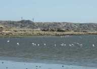
Les flamants roses de Second Lagoon |
Les flamants roses de Second Lagoon |
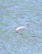
Un flamand rose de Second Lagoon |
Des bateaux dans Robert Harbour |
|
The pink flamingos of Second Lagoon |
The pink flamingos of Second Lagoon |
A pink flamingo of Second Lagoon |
Some boats in Robert Harbour |
|
|
|
|
|
 |
 |
|
|
|
L'océan au crépuscule |
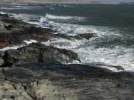
La côte |
|
|
|
The ocean in the twilight |
The coast |
|
|
|
|
|
|
|