|
|
|
|
|
NIGER |
 |
NIGER |
|
Avril 1986 |
|
April, 1986 |
|
La Montagne de l' AÏR |
|
The Mountain of the AÏR |
|
Massif montagneux du
Sahara |
|
Mountainous massif of the
Sahara |
|
400km du nord au sud et
240km de l'est à l'ouest |
|
250 miles of north in the
south and 150 miles of the east in the west |
|
Point culminant : 1944m au mont Greboun |
|
Highest point : 6378 feet
with the Greboun mount |
|
Située dans le centre-nord du Niger |
|
Located in the center-north of Niger |
|
|
|
|
|
Carte de situation dans le pays |
 |
Map of position in the country |
|
Carte de la région |
|
Map of the area |
|
|
|
|
|
|
|
|
|
 |
 |
 |
 |
|
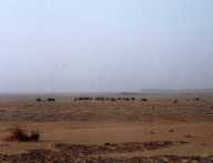
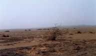
Plateau aride du massif |
Plateau aride du massif |
Végétation minimum |
Végétation minimum, l'aridité règne en
maître |
|
Arid plateau of the massif |
Arid plateau of the massif |
Vegetation minimum |
Vegetation minimum, the aridity prevails as
a master |
|
|
|
|
|
 |
 |
|
|
|
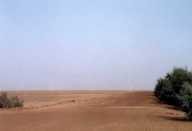
Piste vers le désert du Ténéré |
Piste vers le désert du Ténéré |
|
|
|
Track towards the desert of Tenere |
Track towards the desert of Tenere |
|
|
|
|
|
|
|